Farms in Little Chalfont before 1889
This article was written by Peggy Lancaster
1889 was the date that the Metropolitan Railway opened the station called Chalfont Road, now known as Chalfont and Latimer. It was the signal for developers to build houses, shops, churches and schools near the station. The name ‘Little Chalfont’ came into being in 1925.
The seven or so existing farms mostly sold their land to the developers so that only the farmhouses remained. These farmhouses are today apparently built of brick but most probably they started off as timber framed buildings as inside they have beams and timber frames indicating this.
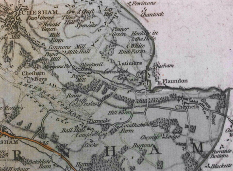
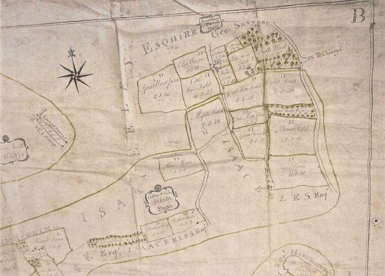
Here are three maps of the area, made at different times, showing the existence (or not) of the farms at that time. The first one is Jeffreys’ 1760 map. Snell’s, Bendrose and Coleman’s Farms are not marked, Coke’s Farm is called Cook’s and Old House is called Hill Farm. Loudham’s Farm and Burton’s are marked but the latter not as a farm.
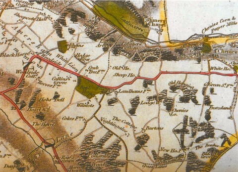
This map is Bryant’s dated 1825. Snell’s and Bendrose Farms are marked but not named. Coleman’s Farm is called Crab Tree farm. Hill Farm is now named as Old House but not Farm and Cook’s is Coke’s Farm. The labelling of Loudham’s Farm and Burton’s remain the same.
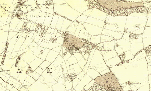
The last map is an OS map of the 1890’s and was made just before the railway line was opened. All the farms are named – Bendrose, Snell’s, Coke’s, Loudham’s, Burton’s and Old House Farms except for Coleman’s (or Crabtree) Farm. It is thought that it was demolished to make way for said railway line.
The 1840 Tithe Maps and apportionments show that the big landowners of the time – The Duke of Bedford, the Hon. C.C. Cavendish, Thomas Tyrwhitt Drake and William Lowndes individually owned most of the farms. The Hon. C. C. Cavendish later became known as Lord Chesham.
The names of the farms probably refer to the names of the tenant farmers at some stage. The names of the farms are also remembered in today’s road names eg Loudhams Road, Cokes Lane and Burtons Lane. Three parishes – Amersham, Chalfont St Giles and Chenies, covered the area.
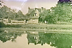
Loudham’s Farm
On some of the earliest maps round about 1735 Loudham’s is referred to as Lowdums. Ivor White in his book came across a record stating that in 1646 the occupier was a tax collector for Charles lst named Thomas Russell.
However even earlier than this, in 1256, there is a record of one hide (between 60 and 100 acres) of land in Chalfont being granted by Hugh de Messenden to Ranulf de Ludham (owner). The name Ludham may therefore be a possible origin of Lowdhams/Loudhams.
The Norward family were tenants in 1688 but later bought it in 1702 for £850 but sold it in 1720 for £1500. In 1820 Lord George Henry Cavendish bought Lowdhams for £3811.
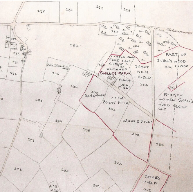
The 1840 Tithe map (map from Centre for Buckinghamshire Studies ref: Tithe/81)
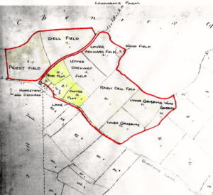
The owner is now the Honourable Charles C. Cavendish and the occupier, David Eggleton. The acreage is 80 acres divided between arable and grass with slightly more arable. The Hon C C Cavendish and David Eggleton also held the same positions in Old House Farm, where David is the under tenant, and Coleman’s Farm. They therefore owned and farmed most of what is now the central part of Little Chalfont.
In the 1841 Census it states that the respective occupiers are:
Loudham’s Farm: David Eggleton 60 Farmer; Eliza 40 (his wife); plus 7 children, 5 boys and 2 girls and 3 agricultural labourers
Old House Farm: Edward Bates 48, agricultural labourer and his family
Coleman’s Farm: Joseph Rose 45, gricultural labourer and his family. It states that it is part of Loudham’s Farm
The Nineteenth and Twentieth Centuries
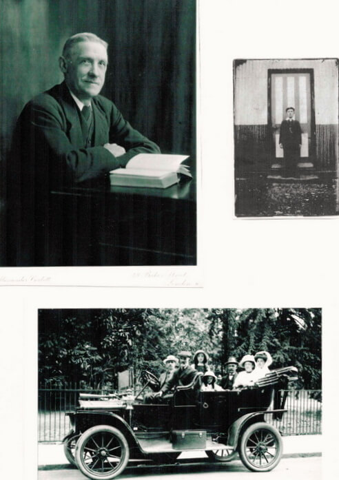
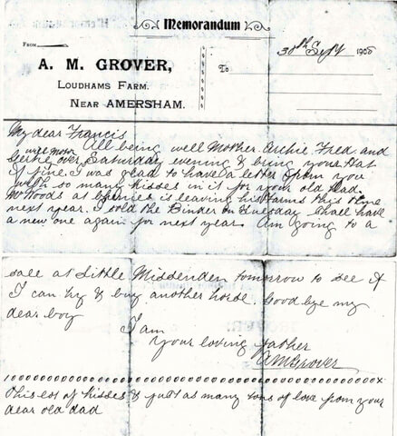
1881 Census: Henry Grover 64, Farmer employing 2 men – 121 acres; Elizabeth Grover 57; Arthur Grover 21; and Archie Grover 19
1891 Census: Archie Grover 29,Farmer; Emma Grover 29; Archie 4; Frederick 2
In 1894 The Duke of Bedford bought Loudham’s Farm plus the surrounding land from Lord Chesham, previously the Hon C C Cavendish. The area for sale included the land north of the main road from the station to Amersham Common and between the road and the railway line. It was offered as building land and The Duke did not like the idea of new housing estates so close to his estate so he purchased it.
1901 Census: Archie Grover 39, Farmer; Emma 45; Frederick 12; plus 3
1911 Census: the Grover family are now living in Loudham’s Cottages and George Bong, 52, is living in Loudham’s Farm.
In 1920 the Duke of Bedford sold Loudham’s Farm to the tenant, Mr Grover, for £2600. At the same time he sold all/most of the land he had bought in 1894 as plots of building land! A definite change of heart!
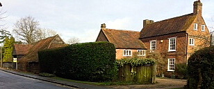
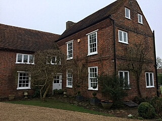
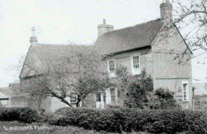
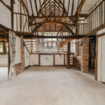
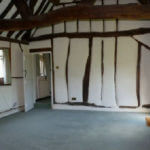
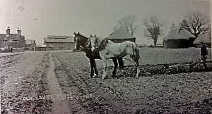
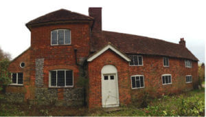
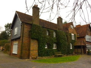
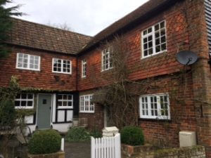
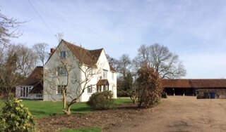
Loudham’s farmhouse is a Grade II listed building. The listing states that the north wing, on the left of photos, is 17th century timber framed with 18th century chequer brick casing and an old tile roof. There is an original central chimney stack. The South wing, on the right of the photos, is 18th century with stepped brick eaves.
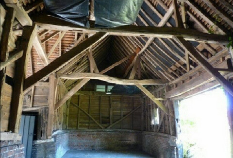
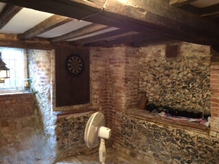
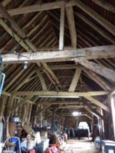
Loudham’s Barn
Looking at the photos of the interiors of the barn that has been converted into a dwelling, the existence of all the beams indicates its previous life as a timber framed building. In the third photo, which is of the barn that will be used for storage or as a garage, the characteristics of a barn are even more evident. [Photos by permission of Wilson Heal]
Old House Farm
Originally this was called Hill Farm.
In 1842 there was an exchange of land with the Hon Charles Compton Cavendish, later known as Lord Chesham, whereby the Duke of Bedford gave up Dell Farm, now Latimer Farm, and its 14 acres , in return for Old House Farm and 32 acres. A note was attached to a survey document which states ‘…..it is a naturally hungry and ungrateful soil and does not tempt men to farm it highly.’
Census Returns
Old House Farm is listed in the Parish of Chenies.
From 1841 to 1901 the occupier of Old House Farm is not a farmer, but agricultural labourers. In most census returns the farm is not mentioned but only Old House Cottages. In the 1841 Census – Edward Bates, 48, his wife Mary, and their 5 children live in old House cottages, but with no mention of the farm. He is an agricultural labourer as is George Mondy, 61, and his wife and Thomas Gallaway, 60, who also live there.
The 1840 Tithe Map (from Centre for Buckinghamshire Studies ref: Tithe/89) and the apportionment, which also comes under Chenies Parish council, names the owner of Old House Farm as The Duke of Bedford and the occupier/tenant as The Honourable Charles Compton Cavendish and his under tenant as David Eggleton. The latter two also own/farm Loudhams Farm where David lives.
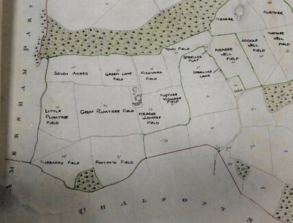
The apportionment of Old House Farm shows that all the fields were arable except Sperlins Plat and Sperlins Lane, both too small to cultivate. The acreage was 142 acres and the rent due to the rector was £39 12s a year.
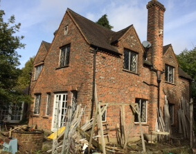
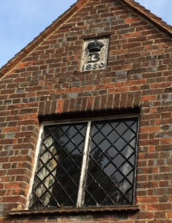
Above right shows the Duke of Bedford’s mark which appears on the buildings he had built in the village of Chenies. There is a similar one on the opposite side of the building above the main door which perhaps indicates that when it was built it was for two families. This is born out by the 1841 Census which states that two families lived there, the men being agricultural labourers, and also Thomas Galloway. Both dwellings had a hearth with a large chimney and a main door. There are no visible beams inside but it probably started out as a timber framed structure.
Coleman’s Farm
The earliest record of the farm is on Bryant’s map of 1825 when it was known as Crab Tree farm. It was at the top of Bell Lane quite near the crossroads by the White Lion Pub. Coleman’s Farm was shown on Estate Maps before the enclosure of the common in 1815 and was included in the 1861 Census when Edward Bates his wife Mary and two other agricultural labourers and their wives also lived there.
The Tithe map of 1840 shows it as Coleman’s Farm but in the apportionment it is labelled as Part of Loudham’s Farm. The owner is the Hon. H H Cavendish and the occupier as David Eggleton but in the 1841 Census David is living in Loudhams and there is a farm labourer living at Colman’s Farm. He was Joseph Rose; his wife Mary Ann and various others also lived there.
It is assumed that when the Metropolitan Railway laid the tracks down prior to 1889 when the station opened Coleman’s Farm was demolished to make way for the railway line. A cottage was built there, Bridge Cottage, but this was also pulled down when Derwent Close was built in the last century. There is no sign today that there was ever a farm there.
Snell’s Farm
There is a record of a Samuel Snell living here in 1684 so probably this is where the name originates. On the early map dated 1763 there is evidence of a brickworks on the farm and in the Census returns there are references to a brick worker living on the farm.
Apart from the field names the apportionment, gives the owners as Elizabeth Charsley and James Rogers. The total acreage was 54 acres and the rent due £11.
1841 Census: Thomas Andrew 25 Farmer and Brick maker; Harriet Andrew 25; 2 agricultural labourers.
1891 and 1901 Census: In both these returns the farmer was Henry Smith and his wife, Sarah. There was also a brick maker living there, an Albert Saunders together with his wife, also named Sarah.
This seems to be the end of Snell’s as a working farm as in the 1911 Census there is a bailiff in residence. As the station opened in 1889 it can be surmised that the farmland was sold for development.
Originally this was most probably a timber framed building. It is easy to imagine that when bricks were first made on the farm one of the first jobs was to reface the farmhouse in bricks. The central section consisting of two windows downstairs plus the door and two or three up was the extent of the original building, with at some time a cross wing and porch added and further extensions at both ends.
By 1911 the farm is no longer a working farm. For further information on Snell’s Farm you can download a large pdf about the History and Heritage of Little Chalfont Nature Park.
Bendrose Farm
A number of parchment documents relating to Bendrose Farm are held by Amersham Museum These are indentures, wills, leases, sales etc – mostly between the following:
1600’s John Harding, John and Richard Bovingdon, Mr H Harding, Mr H Weedon and John Hunt
1700’s John Hunt, John Bovingdon, John Harding and William Garrett
1800’s John Harding, John Swale, George Lawson, Charles Sargeaunt and John Garrett
1840 Tithe Map and Apportionment
The map shows the extent of the farms with the field names inserted. The owner of Bendrose Farm is Charles Segeaunt (note that his name is mentioned in the parchment documents referred to previously) and the occupier is William Partridge. The acreage is 52 acres and the rent due to the rector £12 11s, 5d.
1841 Census for Amersham
Bendrose Farm; William Partridge aged 36 Farmer; Mary Ann Partridge aged 25;3 agricultural labourers and 1 woman employee.
Bendrose Farm today
It is now called Bendrose House and divided into two dwellings, East Bendrose House and West Bendrose House. East Bendrose seems to be the most likely site of the original farmhouse.
Coke’s Farm
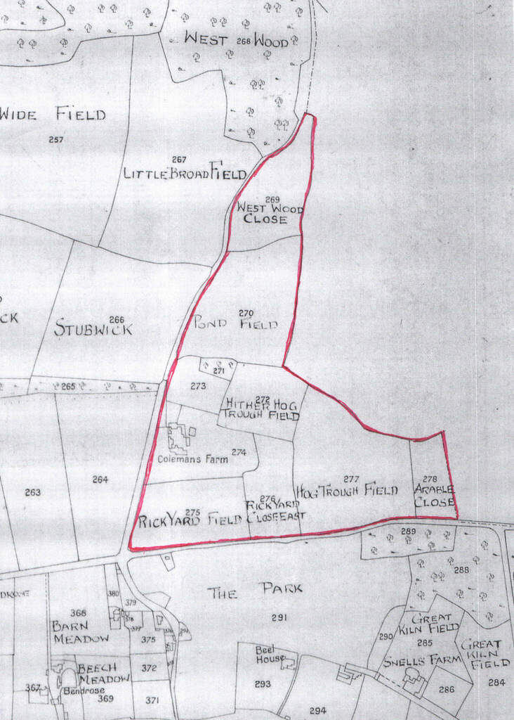
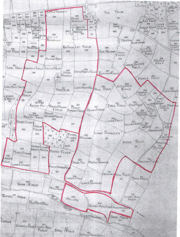
In Jeffrey’s map of 1770 Coke’s Farm appears as Cook’s farm, but in 1825 Bryant’s Map shows it as Coke’s Farm. In the Tithe map, it can be seen that it extends right down to the London road and beyond to the River Misbourne (see the map in the Bendrose Farm section above).
The apportionment shows the owner as William Lowndes esq. and the occupier as William Campion. The farm seems to be half arable and half grass. The total acreage was 191 acres with £44 19s payable to the rector.
1841 Census of the Parish of Amersham
Coke’s Farm; William Campion, aged 30, Farmer; His wife and son aged 4; three employees
1881 Census
William Gee 49, farmer employing 7 men and 3 boys – 251 acres; Emma Gee 50; Earnest (son) 20
1901 The family moved to Latimer.
Coke’s Farm today

The photo on the left above shows the farmhouse today looking at the side that would have been facing the farmyard. The brick is Flemish Bond and it was probably originally a timber framed structure as the interior has many beams.
There is a central chimney stack and a cellar. The latter was most probably used as storage for coal as the shute is still visible, as can be seen in the photo on the right above. Notice that flints were used in its construction.
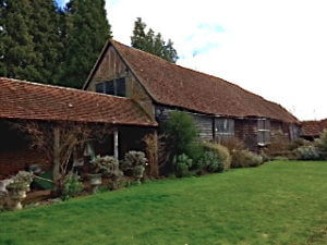
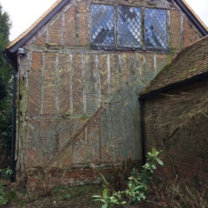
Burton’s Farm
An early record of Burton’s Farm is in 1511/12 when Robert Brudenell bought “the messuage, lands, tenements, meadows, leases, pastures and woods with their appurtenances called Burtons”. In 1660 Sir Wm Drake purchased the property and it was still owned by the Drake family in the 1841 Census.
1841 Census
Burton’s Farm is listed in the Chalfont St Giles parish. Ephraim West, 20, ag. Lab. is living on the farm, but in the apportionment of the Tithe Map 1840 the owner is stated as Thomas Tywhitt Drake and the occupier as Joseph H Gurney.
At that time the farm was 100% arable, except for the orchard, with the acreage 173acres and the annual rent due to the rector £39.
1881 Census
George Bong aged 48; Farmer employing 17 men and 6 boys; Sarah Bong aged 49
In the 1890’s the Tyrwhitt Drake family gave Burton’s Farm, of 180 acres, to the Amersham Almshouse Charity. In May 1913 The Trustees of the Amersham Almshouse charity, or the Amersham United Charities by which name it was now known, auctioned Burton’s Farm in the Railway Hotel for £8,600.
1840 Tithe map showing the extent of Burton’s Farm and the field names (based on a map on www.chalfonthistory.co.uk)
Burton’s Farm today
This photo shows that the farmhouse was separate from the farmyard and barns. There have been additions to the original farmhouse. Possibly the small section to the left was the original farmhouse. Like the other local farmhouses it probably started off as a timber-framed building
A History of Little Chalfont by Ivor White
www.ancestry.co.uk
Centre for Buckinghamshire Studies, Aylesbury – the map department
Amersham Museum
Wilson Heal Estate Agents, Little Chalfont
Chenies and Chorleywood in Camera by Clive Birch
Maureen Grover
Alan Cook
The present occupiers of the farmhouses
John Dodd – www.chalfonthistory.co.uk