By Alison Bailey
For the second of a series of articles on the etymology of our local place names Click here to read the first article, I have looked at those names inspired by nature and Amersham’s rural past. In the previous article I observed that many of our local placenames were inspired by notable residents. However, many also reflect Amersham’s rural past such as Cherry Lane when the area was famous for its cherry harvest. Different native trees feature in names such as Oakway, The Willows, Laurel Court, The Grove, Oakfield Corner, Sycamore Road and Elm Close.
As discussed in the previous article sometimes we have different versions of the origins of place names. Gore Hill is a good example of this and does suggest that Amersham perhaps had a violent past. Gore Hill was supposedly named after a 9th century battle with the Danes, so fierce that the blood ran down the hill. However, there is no record of such a battle in the area. In fact, a gor was a triangular enclosure of land between various large fields. Early maps show one triangular field, called Gor Field to the south of Bury Farm and the road follows this field boundary! Other place names were inspired by historical events and can be self-explanatory such as Lollards Close, named for Amersham’s Protestant Lollard martyrs burnt at the stake in the early 16th century.
The origins of village names
Chesham Bois is named after the neighbouring town of Chesham which was Caesteleshamm and then Cestreham. Caestel is the early word for castle, usually of Roman origin. A Roman estate ran along the river from Sarratt to Waterside and ruins were still visible in Saxon times. Ham or hamm is the Anglo-Saxon word for a settlement or village in a water meadow. Therefore, the name most likely means Roman castle in a water meadow. Bois derives from the de Bois family who were early Norman Lords of the Manor.
Chalfont was known as as Celfunte in the Domesday Book which is most likely derived from the Old English for chalk spring – cealc funta.
Misbourne river
The bourne is derived from the Old English burna for stream or river, but the etymology of the first element is uncertain. It has been suggested that it comes from a lost Old English word related to English moss, and to Danish mysse and Swedish missne, which denotes water or marsh plants. Misbourne could mean river where water-plants grow. Unusually the river Chess took its name from the name of the town, Chesham, and not the other way round.
Chesham Bois Manor
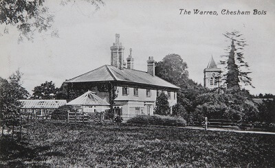
Chesham Bois Manor, the seat of the Cheyne Family was demolished in the early 19th Century but echoes of the estate remain in local place names such as Manor Farm (now The Manor) and Long Park. The early maps also shows Long Walk, a tree lined walk from the manor house to where Anne’s Corner is today. By the 18th century the parkland was being farmed and known as Long Park field. A house beside the church which is believed to the first manor house in the village is now known as The Warren. A warren was part of the manorial estate land, which was enclosed and set aside for breeding game, especially rabbits.
Topography
Whielden Street may take its name from the 14th century William de Whildene, but another interpretation is that the word Whielden came from the Old English hwael meaning curve and dene meaning valley. When Whielden Street becomes Whielden Lane it is curving away among the hills towards Penn and High Wycombe and could therefore mean a curving valley.
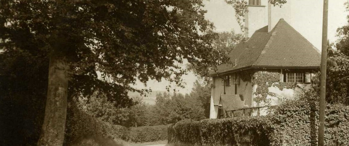
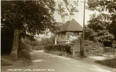
Holloway Lane derives from the Old English hola weg, a sunken road and usually denotes a very ancient path or track. With Bois Lane this follows the route of a pre-historic track from Ley Hill towards Amersham and Penn.
North and South Road were both named for their location to the north and south of one of the most important features in the landscape, Chesham Bois Common.
The naming of Station Road is self-evident but it also tells a story. Station Road was built on the route of the footpath from the town to Amersham Common to give the towns folk, and particularly the horses, a gentler gradient to follow to get to the new station. The steep climb of the existing road, Rectory Hill (named of course for St Mary’s Rectory located here) would have been treacherous in bad weather.
Copperkins
Copperkins Lane is another mysterious local name. Tradition has it that the name derived from copper skins. Named after Romanies who frequently travelled the road to a meeting point at Hyde Heath Pond. However early maps show that local woodland was known as Coppercoins Dell, presumably after a long forgotten archaeological find. By the 1900 map this had become Copperkins Dell. The 1838 map also shows the wonderfully named Maggotycroft Dell on Bois Farm land but rather disappointingly this has never been chosen as a local road name!
Yeomen Farmers
Amersham’s numerous farms are another source of local place names. The farms were usually named for early yeomen farmers and kept the same name for many generations, although often with different spellings. Early maps show Hyrons Farm as Heroynes Farm and today we have Hyrons Lane. Lowdhams or later Loudhams Farm, which gives us Loudhams Road and Loudhams Wood Lane, originates from 1256, when there is a record of one hide of land in Chalfont being granted to Ranulf de Ludham. Mantles Green farm’s origins could be even earlier. The 1086 Doomsday Book shows that Thurstan Mantle held ½ hide and land for two ploughs and 30 pigs in Amersham.
Quarrenden Road, Mayhall Lane, Snells Lane, Little Reeves Avenue, Burtons Lane and Cokes Lane, Woodside Road and Chestnut Lane all derive from the names of the neighbouring farms. Many generations of the Batchelor family farmed and worked as labourers in Amersham. Whilst Batchelors Farm was on the common at Chesham Bois, Batchelors Way in Amersham takes its name from Batchelors Wood on the hill above Amersham which was later owned by the Wellers and developed after the arrival of the Metropolitan Railway.
Field names are also echoed in the place names. Piggots Orchard is derived from the earlier spelling of a field called Pightle or Pytle, an Old English word for a small field or enclosure. Stubbs Wood is derived from the field name Blackwell Stubbe which belonged to the Blackwell Hall farm estate in the valley below. Hundred Acres Lane follows the boundary of the field which had the same name.
The Stanleys
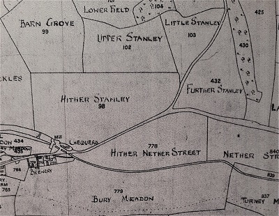
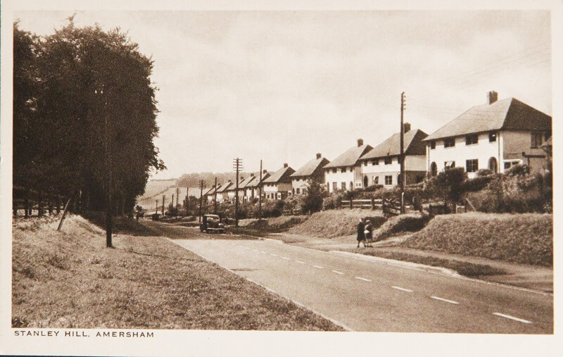
Amersham has quite a proliferation of Stanleys, from Stanley Villas on Station Road to Westanley Avenue, Stanley Hill Avenue and Stanley Hill. It was said that these were named by a young ambitious architect Stanley Hinge Hamp whilst he was working locally at the beginning of his career. Stanley Hamp did become very successful as a Fellow of the Royal Institute of British Architects and is perhaps best known locally for the design of Beaconsfield Golf Club, Davenies School, and for the 1930s modernist houses he designed in Windsor Road, Gerrards Cross, and Cambridge Road, Beaconsfield. However, maps of the area show that there were four large fields called Upper Stanley, Little Stanley, Hither Stanley and Further Stanley so this is probably the true origin of the road names. Stanley’s daughter, Mary Christian Hamp, did give her name to Hampden Hill, her development of distinctive mid-century houses in Beaconsfield, which was built in 1963.
Artisans
Several place names also reflect the names of local craftspeople who lived or worked in a particular location. Norwood’s Court, previously Norwood’s Yard off the High Street was named for Richard Norwood, a currier and leather worker who lived here in the 1740s. Grimsdells Lane in Amersham-on-the-Hill was named after the many generations of Grimsdells, who were blacksmiths, and had their home and forge here on Amersham Common.
The name Bricky Pond, however refers to a local industry, brick making. The clay soil of Chesham Bois Common was frequently dug up to make building bricks in the kilns in a neighbouring field.
High & Over
More recently the 60s development Highover Park was named for the important Grade II* Listed Amyas Connell house, High & Over which was built there in 1931. The house was commissioned by Professor Bernard Ashmole and his wife Dorothy, who named the house after a hill, near Alfriston in Sussex, known to her family.