This article was written by Geoff and Shirley Sherlock about a talk given by Alison Doggett in 2004
 On a cold winter’s evening the Market Hall was packed to hear Alison Doggett give a superbly illustrated and enthusiastic talk about her beloved ancient Chiltern countryside.
Alison’s first challenge was to define the Chilterns and she decided that the Chiltern hills provided a landscape like no other, a highly unusual, special region and a divide between the clay vale and the London Basin. Her description of the chalk petticoats decorating the cultivated, sloping fields was a lovely piece of evocative imagery. Amazingly, this special area still shows much clear evidence of its ancient history and yet it is so close to London. A recent Chiltern Society survey found that this ancient landscape “enjoyed” some 50 million visitors a year.
The medieval documentation, which is plentiful, is spread over four counties. For example the village of Codicote, near Knebworth in Hertfordshire, has a Court Book that gives detailed land holdings in the 13th century and even has a record of one John Doget who held 15 strips. He enclosed these quite early on but apparently did not make his fortune. Towards the western end of the Hills the records of the village of Turville, Bucks show enclosure also in the early 1300s, and the windmill. A windmill still exists on the site and it can be seen for a long way around but Alison describes reaching it as ‘a desperate climb’.

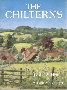
Any view of a Chiltern landscape will show patches of woodland hanging on the hilltops’ edges. This we saw in a slide of Brian Bennett’s painting of Turville, which also forms the cover of Alison’s book on the Chilterns, depicting the red- roofed village sheltering in the valley bottom, half hidden in the hedges and the grey, flint-built church with its squat tower. There are no soaring spires in the Chilterns because the local flint and chalk is not strong enough as a building stone. Follow the escarpment foot, the spring line for water supply, and you will not see any large churches, but you will find ancient ones with medieval wall paintings, such as Little Kimble.
Brian Bennett’s landscape is a reflection of a scene, some 500 years earlier illustrated in John Blagrave’s map (1586) of the Harpsden valley south west of Henley. The scattered individual houses are clear as are the small, hedged fields cut out of woodland – a process known as “assarting”. The sunken lanes are still there and used today, the only real difference being a narrow strip of tarmac; they are often named after their original description of ‘hollow ways’.
In contrast to the enclosed, mixed farming scene of Harpsden, Alison’s second map (1598) of Lewknor in the Vale of Aylesbury, showed no hedges, little woodland, huge open fields and nucleated settlement. As the map was drawn for All Souls College, Oxford, it shows only the strips belonging to the College.
The effect of geography rather than history on the landscape is best shown by one of the parish boundary maps that Alison showed us. The long narrow parishes stretching up from the Vale to the hilltops provided a range of land uses from the clay lowlands, the spring line villages like the Kimbles, the woodland on the scarp edge for “hillwork” i.e. collecting wood for fires and the downland crest scrub for sheep. Beyond the crest, on the dip slope, is the managed woodland for cattle and pigs.
The woodland is of two main types: the enclosed woodland used for standard trees for building timber and coppiced hazel and beech wood for domestic articles, fencing and wattle and daub. The beech coppice wood was also very good for charcoal for home and sale, especially to London. Around the enclosed wood is usually a ditch and bank. The bank is topped by a stock-proof hedge.
Trees outside this woodland were usually more widely spaced and “pollarded” i.e. the trunks were cut at a height above the reach of grazing cattle. The animals grazed the open land between the trees and the pigs rooted for acorns and kept the ground clear . These more sheltered farmlands on the dip slope often became daughter parishes for some of the scarp settlements. On the map these parish outlines are more rounded and compact. Some of these daughters were no doubt happy to escape, for example Coleshill was probably very relieved to be away from mother Tring.
The Chiltern wood was very important both locally and for London as it supplied vast quantities of charcoal as well as building timber. The charcoal trade fell away with the coming of the canals that brought coal from the Midlands for the towns and cities. This competition invigorated the already existing local furniture industry into a very rapid growth. The managed beech woods supplied excellent raw materials for chair-making for the rapidly-expanding industrial population of London.
This was the time of the small workshops in the villages around High Wycombe and in the town itself. Most people have heard of the Chiltern bodgers, men who cut the wood and worked pole lathes in the woods to produce the millions of chair legs needed.
The photos that Alison showed inevitably gave a somewhat rosy view of life in the woods. The weather always seemed to be good and stops for tea around a blazing fire of wood shavings suggested an idyllic “noble savage” kind of existence. In the wet and the cold the reality must have been somewhat different.
However, it was this somewhat romantic view of the Chilterns that brought major changes to the area in the period between the two World Wars. The London Underground advertised days of glorious walking in the countryside, encouraging the tourists with special excursion tickets that linked different stations. Builders advertised the rural life of the railway commuter and flat-pack bungalows “Cottabunga – £245.10.0d.” were sold for rapid building before the advent of modern planning rules.
This development of modern tourism and expanding “Metroland” building brought impassioned protests from authors such as Massingham and Clough William-Ellis who reviled the “octopus” of urban sprawl. The CPRE was also in the lead with its “Save the countryside” campaign. Today the pressure on the greenbelt land in the Chilterns is a frequent topic of conversation. Organisations such as BBOWT (Bucks, Berks and Oxford Wildlife Trust) play a large part in the protection of the landscape. For example, they maintain a flock of sheep to keep the grasses closely cropped. Alison’s graphic photo of these sheep in winter at the Aston Clinton ragpits gave us a hint of this conservation policy and of her devotion – she took the photograph while her leg was in plaster! Alison Doggett finished her rapid tour of 1500 years of Chiltern geography and history with her current work with the Chiltern Society to get the whole range of hills from, roughly, Hitchin in the east to Goring in the west designated as a special planning sub-region. This means that the area protected would be about double the current AONB and that there should be an overall coherence in the planning policies of all local authorities.
By its nature the Market Hall audience was very supportive of the Chiltern Landscape but by the end of Alison Doggett’s talk it was much better informed and ready to walk in the Hills and to see them with a much clearer vision.

