This is an intriguing article by Peter Borrows which almost throws up more questions than it answers. But in it we learn the origins of some local place names looking through the detail our ancestors went into.
In order to make research on the Amersham Tithe Map of 1838 easier, I have recently been transcribing the entries in the apportionment onto a spreadsheet. Tithe maps were created as a result of the Tithe Commutation Act 1836, which aimed to convert traditional tithe payments (a tenth of agricultural produce) into monetary rent charges. These maps, along with the apportionments (which are detailed schedules), were produced to survey and assess the land within a parish for tithe purposes.
Tithe maps were produced locally, often using existing maps as a base, and had to be approved by the Tithe Commissioners. While the goal was high-quality mapping, the expense involved led to some variations in accuracy and detail across different parishes. The Surveyor for the Amersham map was James Stratford. In the 1841 census he was living with his family in the High Street in Amersham, although I haven’t yet worked out in which house. Interestingly, his father, Richard Stratford had been the Surveyor for the Amersham Inclosure (sic!) Map of 1815. James’s two sons (James and Richard) both seem to have joined the family business as surveyors and auctioneers.
On the map, every plot of land is numbered. To find the name and other details about the field, etc you then need to look at the apportionment. Although there are a number of versions of the Amersham tithe map available, I used the diocesan copy of the map which is held at the Buckinghamshire Archives, currently in Aylesbury, but soon to move to High Wycombe.
The apportionment lists just over 1200 fields, woods or plots on which there are buildings. For each one, it gives the name of the landowner, the occupier, the name of the farm where relevant, whether the land is arable, grass or woodland, the area (in perches, roods and acres[1]), the tithe (in pounds, shillings and pence[2]) and the name of the field. The spreadsheet allows you to see how wealthy particular landowners were, which fields were parts of which farm, or to sort the data in any other useful way.
It can be very difficult to identify the location of a particular field so I used freely available geographical mapping software, QGIS, to identify the coordinates (using Ordnance Survey eastings and northings) of each field (although doubtless I made some mistakes). The software also enabled me to superimpose a semi-transparent version of the tithe map onto Streetmap, so that I could see where each field was located in relation to current roads, etc.
There is a variety of names used for the fields. Some are quite mundane, like Middle Field (386) or Nine Acres (924) but others are more intriguing. What is the story behind Great Pains Field (713)? You would have sympathy for the woman (yes, woman) who farmed Stoney Rocks (949). You might guess a previous (or current?) use of Potkiln Meadow (993), Burying Ground (222), Burying Orchard (324), neither of the latter corresponding with cemeteries associated with churches, chapels, or the Quakers. And how or why did field 361 get the same Isle of Wight? Could it be something to do with the imprisonment of Charles I in Carisbrooke Castle?
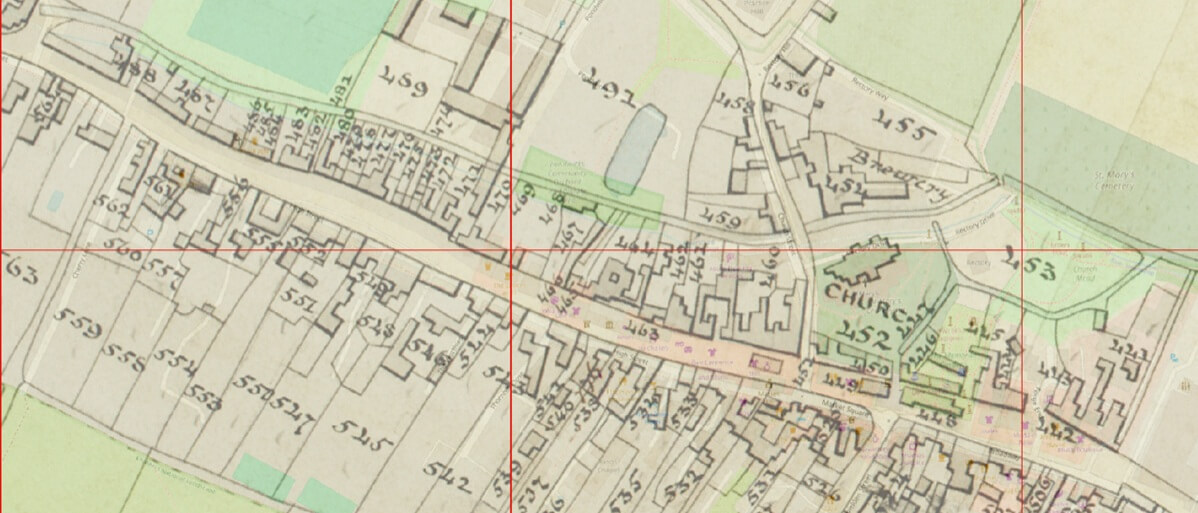
There are five fields with windmill in the name. Four of these, Little Windmill Field (71), Great Windmill Field (72), Hither Windmill Field (80) and Windmill Field (81) are in the area now largely occupied by Hervines Park and the sports fields of Dr Challoner’s Grammar School (see Figure 1). Ironically, the area we now call Windmill Wood is just to the west of these, mostly in Baldwin’s Field (69). Anyway, surely you wouldn’t build a windmill in a wood, because it would be partly sheltered from wind?

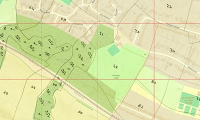
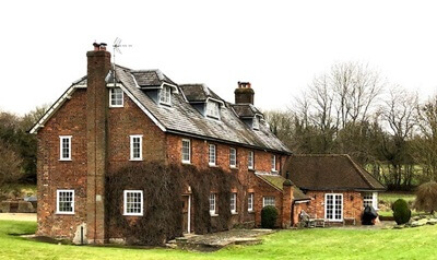
But what about the fifth field on the tithe map, also called Windmill Field (835), (see Figure 2)? That’s about 3 km south-east of the others, between Quarrendon Mill and Quarrendon Farm. That’s very odd because Quarrendon Mill is (or was until it fell out of use in the early years of the 20th century) a watermill built by William Holding on land leased from William Drake in 1766 (see Figure 3, photo Peter Borrows). Indeed, it is shown as such on the tithe map as Mill Meadow (844). So was the watermill preceded by a windmill further up the hillside? Watermills are usually considered technically easier than windmills, so if you’ve got a reasonable supply of water, why build a windmill?
Admittedly, William Holding did have to construct a mill leet (channel) to get the water to where he needed it, away from the valley bottom, and that caused all sorts of flooding problems, only solved recently by work carried out by Affinity Water. Some support for the idea of a windmill is given by the place name Quarrendon which is believed to derive from the Old English words cweorn, meaning mill (related to modern English quern and possibly corn) and dūn, which means hill, so perhaps there was once a mill on a hill here. I had always assumed that the name came from the village of Quarrendon some 30 km away, north of Aylesbury, perhaps because the farm was once owned by somebody from that village, but perhaps there really was a windmill there. Does anyone have any other evidence?

The tithe map also gives some clues as to how Hervines Park got its name. The Park is pretty much coincident with Great Windmill Field, plot number 72 (see Figure 1), one of more than 40 fields comprising Heroynes Farm. The land was owned by Thomas Tyrwhitt-Drake and farmed by James Williams. The farmhouse was on plot 117, on what is now Hyron’s Barn on Woodside Road (Figure 4). I find Heroynes quite difficult to pronounce, so it is not surprising that it turned into both Hyron’s and Hervines over the years. The Enumerators of the Census seem to have encountered similar problems because on the 1841 Census it is called Herron’s Farm and in 1851 and 1871 Heron’s Farm but in 1911 it is Hyron’s Farm and 1921 Hyson’s Farm! However, in the emergency register drawn up at the start of the war in 1939 there was both Hyron’s Lodge and Hyron’s Old Barn.

When the Amersham Museum cautiously resumed its guided Tudor
Walks after the Covid-19 lockdown (remember? 6 people meeting outdoors, so 1 guide and no more than 5 visitors) we were keen to make them relevant and topical. So, in the section on health in Tudor times, we referred to various plagues and pointed out that self-isolation was nothing new. Amersham had its Pest House, with its own plague pit. It was established in 1622 at Gore Hill House (Figure 5, from the Amersham Museum) on the road to Beaconsfield. Parish Accounts show a payment of £2 16s 11d “for the relief of such as were suspected dangerous to the parish in time of infection.”

The tithe map overlaying the modern Street Map (Figure 6) shows exactly where it was (plot 756) – and why it had to be demolished when the country lane up Gore Hill was straightened and widened in 1964.
Peter Borrows
This article was originally published as Some thoughts on the Amersham Tithe Map in the Amersham Society Newsletter, January 2026.
[1] 40 perches = 1 rood, 4 roods = 1 acre 1 acre ≈ 4 000 square metres
[2] 12 pence = 1 shilling, 20 shillings = 1 pound 1 old penny ≈ 0.4 (new) pence