This article was written by Peter Borrows and first appeared in the Amersham Society Newsletter in May 2017
Residents of Whielden Street sometimes feel they are the poor relations of those in the High Street but, in one respect, Whielden Street is unique. Every other town has its High Street but there is no other Whielden Street. So how did it get its name?
You may be told it was called Union Street in the 19th century, named after the Workhouse for the Amersham Union of Parishes, built in 1838. This is only partially true. In the censuses of 1861, 1871, 1901 it was indeed called Union Street but on the 1878 and 1898 Ordnance Survey maps and in all the other censuses it was Whielden Street. In fact, even that is not quite true: in 1841 and 1851 it was Wildon Street, reflecting centuries of uncertainty about the spelling.
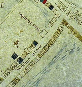
When researching the history of our house[1], my wife and I looked at many documents, especially from the 18th century, and found a dozen or so variations on the spelling, including Weilden, Whildinge, Wielding, Whylden, Whildon, Whilden, Wildon, Willendon, Wheeldon, Wheelden and Wheildon. One that will be known to many readers is from the1742 map (Fig. 1) drawn up for the Drake family, where it is clearly Wilding Street, which gives a clue to the pronunciation at the time. The oldest reference is found in the 1487 will of William Saunders of The Bury (Bury Farm). He leaves most of his property to his wife Isabella, except for a house situated in ‘Weldon Street’ in which William Wadesley was living and after his death to the Brotherhood of St Katherine.
The Victoria County History of Buckinghamshire[2], published in 1925, says: On the south side of Amersham High Street, Whielden Street, which may take its name from the 14th-century William de Whildene, (fn. 38) leads past the General and Particular Baptist and the Wesleyan chapels with their cemetery, and past the union workhouse, and as Whielden Lane reaches Coleshill, nearly 2 miles south.
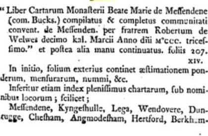
The reference fn. 38 is to a document which at the time was in the British Museum, now the British Library, Harl. MS. 3688, fol. 75 d. This is a misprint for Harl. MS. 3688, fol. 75v but, in any case, most of the items in the Harley Collection are not listed in the British Library Archives and Manuscripts and have certainly not been digitized. A catalogue of the Collection, drawn up in Latin in 1808, is available on Google Books[3]. Fig. 2 shows a short extract from which it seems that the manuscript concerns possessions of what we now call Missenden Abbey, including some in Angmodesham (Amersham). The actual reference to William de Whildene in the original document is shown in Fig. 3[4].
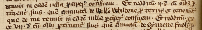
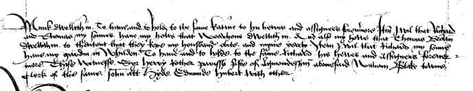
In medieval times a man usually took his name from the place where he lived and so the assertion in the Victoria County History is probably wrong. However, we can get a clue as to the location of Whildene in a document in the National Archives, Chancery pleadings addressed to Thomas Wolsey, Lord Chancellor, in which William Smyth[5], husbandman, takes action against Robert Cooke, ‘wheler’ (wheelwright) because of a refusal to complete the sale of a tenement in Agmondesham and Pen (Amersham and Penn), ‘some time called Sylvesters Wheledene and now Cookes in the counties of Buckingham and Hertfordshire’. The first part of the document is shown in Fig. 4 (the reference to ‘Sylvesters Wheledene’ is at the righthand end of the 4th line).
According to John Chenevix Trench’s history of the houses of Coleshill[6], The Queen’s Head (now a private house on Whielden Lane, north-east of Winchmore Hill) was known as Coke’s, after an early 16th century owner. The area around The Queen’s Head is still called Whielden Gate and this is probably where William de Whildene lived. ‘Gate’ refers to the 18th century toll house, built here on the Hatfield to Reading turnpike.
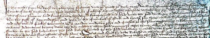
It is probable that Whilden was in the possession of the Saunders family. In her will[7] of 1497 Isabella Saunders, wife of William Saunders (whose own will of 1487 has been referred to above) left a garden at Whilden to their son Richard Saunders (see left hand end of 4th line of Fig 5). According to the Certificate of Musters[8] in 1522 Richard, a dyer, was one of the richest men in Buckinghamshire with land in Amersham worth £6-13-4 and £300 in goods, five times what the next richest man in the town owned. In 1521, he had been fined £20 for allowing his house to be used for Lollard conventicles (meetings where the Bible was read in English and prayers were said in English). In turn, William and Isabella’s daughter Sybill (or Isabel), (probably the wife of John Scrivener, burnt as a Lollard in 1521), in her will of 1526[9] leaves various items to her daughter Katherine Coke, presumably of the Coke family mentioned above.
Eustace Alliott, writing in 1960[10], said that the word Whielden came from the Saxon (scholars would now say Old English) hwael meaning ‘curve’ and dene meaning ‘valley’. It is difficult for the modern traveller to see the curve of the valley, partly because Whielden Street and its continuation into Whielden Lane have been re-aligned and now the A404 is much more important than Whielden Lane. However, the Hatfield to Reading turnpike followed the line of the old Roman road and (the remains of) it can still be seen as a footpath diagonally crossing the field behind Tesco, going down from near the martyrs’ memorial. On reaching the cemetery, the path now turns right between the river and the cemetery but originally would have crossed the river at a shallow ford. (The brick bridge about 200 m to the right is said to have Roman foundations but was not the original crossing). The route would have carried on in a straight line through the present Old Town car park, crossing The Broadway and under the archway of The Griffin Inn into its yard and then joining Whielden Street at Whielden Green. This straight road down hill and through the town then curves round as it climbs towards Winchmore Hill and on to Penn.
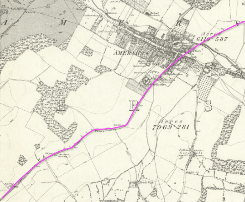
Imagine you are a Saxon trader coming down into the Misbourne valley from the Hatfield direction. There are, perhaps a few huts on the opposite bank of the river but not the buildings that now line Whielden Street. Your way is straight down to the ford and then curves gently as you climb the valley on the opposite side. You lose sight of your route ahead as the track curves round from Whielden Street onto what is now the A404. It’s hard to see now, but this was the curved valley.
The Roman road was not a major route, not a military route, and almost certainly followed a prehistoric trackway. Such trackways often used large boulders, sarsens, to mark the route across country. Two such sarsens are now set into the pavement in the Broadway next to the exit of the Old Town car park and another in the wall of the yard of the Griffin Inn.
A number of wills, indentures, marriage records and other documents from the 16th, 17th and 18th centuries show close links between Amersham and Penn. For example, the land our house in Whielden Street was built on in 1702 had previously been owned by John and Mary Daveney of Penn. In those days, Whielden Gate, Winchmore Hill and Penn were ‘just up the valley’ from Amersham.
The various spellings throw into question the pronunciation of Whielden. Today, we rhyme the first syllable with ‘field’, but obviously in 1742 it rhymed with ‘wild’. How was hwael pronounced?
Notes:
- [1] https://amershammuseum.org/history/research/other-articles/house-history-detective/
- [2] http://www.british-history.ac.uk/vch/bucks/vol3/pp141-155
- [3] goo.gl/pp33Gq
- [4] © British Library Board Harl. MS. 3688, fol. 75v
- [5 The National Archives, C 1/443/25 dated between 1515 and 1518.
- [6] http://www.bucksas.org.uk/rob/rob_25_0_61.pdf
- [7] The National Archives, PROB 11/11/93.
- [8] http://www.bucksrecsoc.org.uk/BRS-VOLUMES/brs-vol-17.pdf (transcription of document in the Bodleian Library)
- [9] Buckinghamshire Record Office, D/A/WE/1561.
- [10] https://amershammuseum.org/history/research/memories/mr-alliotts-notes/
- [11] This is a combination of the OS maps held by the Amersham Museum (Amersham) and the National Library of Scotland (Winchmore Hill).